DroneSense is a comprehensive platform that empowers public safety, government, and critical infrastructure organizations to effectively use drones for situational awareness, crime prevention, and emergency response. With DroneSense, responders gain a full picture of unfolding situations, enabling better decisions and proactive hazard identification. Whether aiding law enforcement in crimes-in-progress, assisting fire services with pre-fire planning, or coordinating emergency management efforts, DroneSense provides a powerful suite of tools. It allows remote drone operation, real-time video transmission, and improved outcomes through technology and situational awareness.
(Licensing per Aircraft)
- Class N UAS License (sub-250g)
- Class N UAS License - 1 year : covers sub-250g UAS
- Includes software license for DroneSense Mobile and DroneSense Web for all organization users and: Initial setup and online training, technical support as outlined in Terms and Conditions, and Fair use storage on DroneSense cloud.
- Includes Drone License in addition to - Advanced VIdeo Sharing and Integrations.
- Class 1 UAS License
- Class 1 UAS License for 1 year: covers DJI Mavic series, Autel, and Parrot.
- Includes software license for DroneSense Mobile and DroneSense Web for all organization users and: Initial setup and online training, technical support as outlined in Terms and Conditions, and Fair use storage on DroneSense cloud.
- Includes Drone License in addition to - Advanced VIdeo Sharing, Advanced Geo-Spatial, and Integrations.
- Class 2 UAS License
- Class 2 UAS License for 1 year: covers the DJI Matrice series
- Includes software license for DroneSense Mobile and DroneSense Web for all organization users and: Initial setup and online training, technical support as outlined in Terms and Conditions, and Fair use storage on DroneSense cloud.
- Includes Drone License in addition to - Advanced VIdeo Sharing, Advanced Geo-Spatial, and Integrations.
- Short Description - supports flight logging of SkyDio aircrafts.
- Includes software license for DroneSense Mobile and DroneSense Web for all organization users and: Initial setup and online training, technical support as outlined in Terms and Conditions, and Fair use storage on DroneSense cloud.
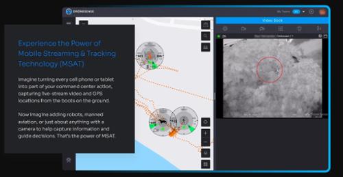
- DSMSAT-P
- Mobile Streaming And Tracking (MSAT)
- Short Description -DroneSense Mobile Streaming: Includes the capability to stream low latency video and device location from any supported phone or tablet running the DroneSense Mobile App on the DroneSense Cloud for up to 1200 hours per year.
- DSRST-P (Required for Remote sales)
- DroneSense Remote Onsite Training
- Short Description - Included with package; 2 day onsite training, set up and support of geofencing per department SOP guidelines.
- DSC1DSR-P
- Drone as First Responder “DroneSense Remote” Class 1
- Short Description - Quantity = Per class 1 drone per year included within package; ability to fly each licensed drone BVLOS* (beyond visual line of sight)
- Drone as First Responder “DroneSense Remote” Class Short Description - Quantity = Per class 2 drone per year included within package; ability to fly each licensed drone BVLOS* (beyond visual line of sight)
- DSIPT2 - (Price is per day)
- DroneSense on-Site One Day in Person Training
- Short Description[1]One day of on site training from the DroneSense Success team at the agency's location of choice.
(Included with Aircraft License)
- Short Description - Magic Video Link
- Quantity = Per drone per year
- Included within package; Contacts / Notification, Magic Video Link (Sharing)
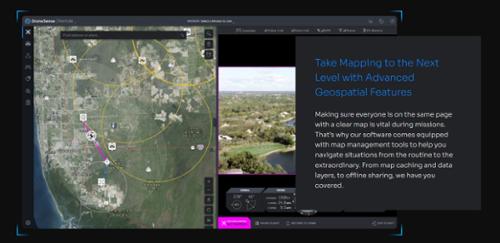
- Advanced Geospatial Features - (Not available with Class N)
- Short Description - Map Layers and Custom Elements
- Quantity = Per drone per year
- Included within package; Tile Ninja (Geotiff/Geopdf maps)
- Short Description - Dock Integration, Airspace Awareness, Terrain Following
- Quantity = Per drone per year
- Included within package; VMS/RTSP Endpoint, ATAK, API Access & Integration, Counter UAS (C-UAS)