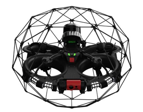


The FLYABILITY ELIOS 3 is an advanced indoor inspection and mapping drone engineered for safe, efficient access to confined and hazardous environments. Its collision-resilient design and protective carbon cage enable reliable operation in GPS-denied spaces, allowing users to perform remote surveys and inspections where human entry is unsafe or impractical. The Elios 3 delivers highly accurate data collection in complex industrial settings, supporting applications such as asset inspection, infrastructure monitoring, and 3D mapping. With LiDAR-based stabilization, live situational awareness, and location-tagged data, the drone provides actionable insights for fast decision-making while maximizing uptime and reducing operational costs.
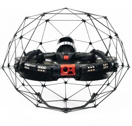
This platform offers unmatched versatility with a built-in visual inspection payload, 4K camera, and thermal imaging, as well as add-ons for ultrasonic testing, surveying, radiation detection, and flammable gas sensing. The Elios 3 integrates seamlessly with advanced software solutions for real-time analysis, 3D modeling, and cloud-based asset management. Its intuitive controls, one-day training program, and dedicated support team ensure rapid onboarding and ease of use for operators in industries such as power generation, oil and gas, mining, and public safety.
|
|
|
Improved safety Reliable data |
Unprecedented access Cost efficiency |
|
DESIGNED FOR INDOORS
|
UNMATCHED VERSATILITY
|
Qty 1- Elios 3 Drone
Qty 1- LiDAR Payload
Qty 9- Elios Batteries
Qty 7- Elios Battery Chargers
Qty 1- Tablet of the Ground Control Station
Qty 1- 1.8m USB Cable, Remote Controller Charger with Adapters, USB Power Plug
Qty 1- Smart Battery Guidelines and Original Instructions Documents
Qty 1- Toolbox
Qty 1- Remote Controller of the Ground Control Station
Qty 1- Adjustable Harness for the Remote Controller with Mounts and Screws Set
Qty 1- Propeller Packs with M5 Nuts (3x pack of 4x propellers)
Qty 1- Transport Case
Qty 3- Range Extender Batteries
Qty 1- Range Extender + its Battery Charger with 2x Extension Cord Set
Set of spare cage elements, which includes different types:
Qty 1- Cage Top Hexagon A
Qty 2- Cage Top Pentagon B
Qty 2- Cage Bottom Pentagon C
Qty 2- Cage Bottom Hexagon D
Qty 1- Cage Triangle