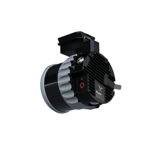

The FREEFLY Flux O1 is a compact, high-performance LiDAR payload built around the Ouster OS1 sensor, offering NDAA and Blue UAS compliance for use in sensitive or regulated environments. With ±3 cm accuracy and 0.5 cm precision, it delivers ultra-dense point clouds at 5.2 million points per second, making it ideal for critical infrastructure inspection, urban mapping, transportation corridor analysis, and government or defense-related geospatial projects. Its lightweight design and streamlined integration make it a reliable tool for operators who need consistent, high-resolution data in the field.
Designed for flexibility and ease of use, the Flux O1 supports GNSS Post-Processing Kinematic (PPK) workflows and outputs in standard LAS or LAZ formats—without requiring software subscriptions or ongoing maintenance costs. Its 200-meter range and 360° × 42° field of view ensure comprehensive coverage, even in complex environments. Whether deployed on FREEFLY Astro or other MAVLink-compatible platforms, the Flux O1 is engineered to meet the demands of professional-grade aerial LiDAR missions.
|
|
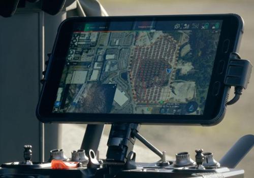
1. PLAN YOUR MISSION LIKE A PROUse your preferred mission planning app to map out your survey. Set the altitude between 10 and 150 meters. Adjust the lateral overlap to match the flight track separation for optimal coverage. Choose a speed between 1 and 15 m/s to balance point density and mission duration. |
2. PRESS RECORD & TAKE-OFFWith a single press of the REC button, you're ready to collect up to 1.9 million points per second. The system automatically syncs IMU, GNSS, and LiDAR data, storing it securely on the USB-C flash drive. Spend less time worrying about equipment and more time focusing on your mission. |
3. SKIP CALIBRATION - FLY FREELYForget about time-consuming calibration passes or tricky flight patterns. Take off vertically, fly directly to your first waypoint, and start surveying immediately. Our advanced processing ensures that strips align perfectly every time. This streamlined approach saves time and boosts efficiency, giving you flawless results faster. |
4. SECURE YOUR DATA IN SECONDSAfter landing, simply press STOP to finalize the recording. Your data is instantly saved to the USB-C flash drive and fully prepared for processing. |
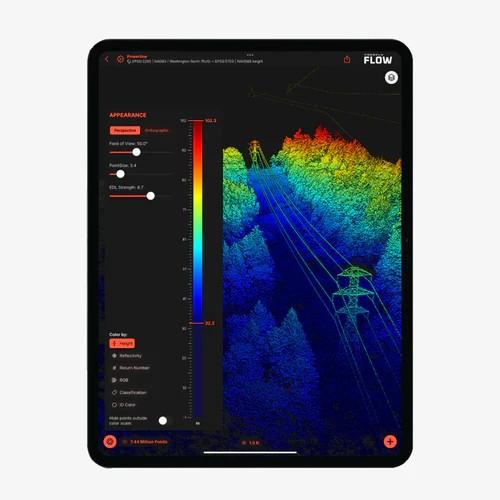
5. PROCESS THE LiDAR DATA ON-SITE IN MINUTESDon't wait to get back to the office. While still on-site, use our app to import the data from the USB-C flash drive into a new project. Add the ground station's RINEX file for the GNSS post-processing. In just a few minutes, a highly accurate, dense point cloud is produced and ready for analysis. It has never been easier to verify and check that the dataset is full and complete. Whether it's vegetation mapping, terrain modeling, or infrastructure inspection, you'll have actionable insights on the spot. |
*Products on this page are subject to U.S. Export Administration Regulations (EAR). They may not be exported, re-exported, or used in violation of U.S. law, including restrictions on destination, end use, or end user. By issuing a purchase order or accepting delivery, Buyer acknowledges these restrictions and agrees to comply with all applicable regulations.
*Full notice available at: https://www.gresco.com/spcu/ipage?code=ExportComplianceNotice and https://www.gresco.com/spcu/ipage?code=EAR-RegulatedTechnologyandEncryptionProductNotice
Qty 1 - Flux O1 LiDAR payload
Qty 1 - GNSS antenna
Qty 1 - GNSS cable
Qty 1 - USB-C cable
Qty 1 - USB drive with software and documentation
Qty 1 - Protective case
Quick start guide